Esigodini (formerly Essexvale)
Most visitors to Esigodini are probably driving through from Beit Bridge to Bulawayo and the Victoria Falls or looking for the turnoff to get to Falcon College.
Esigodini is on A6 National Road to Beit Bridge about 64 kilometres from Bulawayo. For Falcon College take the road from Esigodini signposted for Falcon College. At 4.8 KM cross the Ncema River Bridge, 10.3 KM arrive at Falcon College entrance.
GPS reference for Esigodini Church: 20⁰17′32.64″S 28⁰56′19.18″E
Esigodini is a village situated on the A6 National road to Beit Bridge and on the branch line from Bulawayo to West Nicholson and Beit Bridge. It is the local centre and administrative centre of a ranching and mixed farming centre and was founded in 1894 with the establishment of the Matabele Gold Reefs and Estates Company Ltd.
Esigodini may mean "in the hollow" or valley, in the local language IsiNdebele as the Esigodini area is known locally as the Esigodini Valley. The area is bounded by two river systems – the Ncema River in the North and the Mzingwane River in the South and is shaped like a large bowl measuring about 30 kilometres north to south and 20 kilometres west to east. The Northern portion is dotted with numerous small kopjes and the Western boundary is dominated by Scoveni Peak and comprises a hill range known locally as the “Blue Hills,” so named because of the colours and hues that paint the hills in the early morning and late evening.
The grass of the district, which was known as Godhlwayo is of an excellent quality, and the area supported large herds of Lobengula's cattle, who once said that the cattle of Godhlwayo were as many as locusts.
The area contains two gold belts on which there were several mines, the largest of which was the Bushtick Mine [see the separate article] now the site of Falcon College, an independent boarding school for boys. The main gold belt originates in the Filabusi district and runs through the estate in a northerly direction. The other branches off near Mbalabala and runs west, terminating in the granites of the Bulalima Mangwe district.
Gold in Zimbabwe occurs almost exclusively in the green stone belts as hydrothermal deposits. The green stone belts are normally composed of volcanic and sedimentary rocks (schist) that have been squeezed into long linear belts about 2,500 million years ago by massive granite intrusions that causes them to become highly fractured and faulted.
The hydrothermal solution was made up of water under high pressure and temperature in which the gold and numerous other minerals were dissolved and was injected into these faults and shears. If minerals such as iron were present in the surrounding rock, the gold, along with other minerals, would be precipitated out. Silica was a common material in the solution and was precipitated out as quartz, a white, glassy, hard rock as the temperature and pressure of the water dropped.
The prospector would therefore walk around in the bush and along river cuttings and look for outcrops of quartz veins that were exposed on the surface and sample them to determine whether they contained gold. Most quartz veins are barren, because for the gold to precipitate, the right minerals had to be present in the surrounding, or host rock. If the gold values were promising after panning samples, a claim would be registered and the prospector might sink an exploration shaft on the quartz vein.
The largest producer was the Bushtick Mine which began as “ancient workings” until registered by the BSA Company and produced over 470,000 oz. (>14,600 kilograms) over its lifetime. Intensive production began in the 1920’s through to the early 1950’s. In its heyday from 1932 to 1947 Bushtick Mine was the biggest producer in the country, but closed down in 1951.
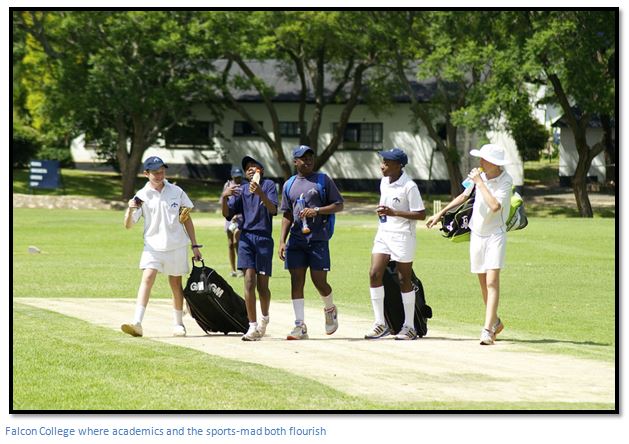
In 1954 the Bushtick mine site became the basis of Falcon College, a higher education level school for boys aged 12-18 years. It is located 10 kilometres from Esigodini. In its early days the school made extensive use of the old mine property and infrastructure. Homes that had housed miners and their families would now house teaching staff and boarding school boys; former mine offices would become administration offices and classrooms and mine facilities, such as tennis courts and a swimming pool, would become school facilities. Since that time, the school has flourished to become one of Zimbabwe’s leading education establishments.
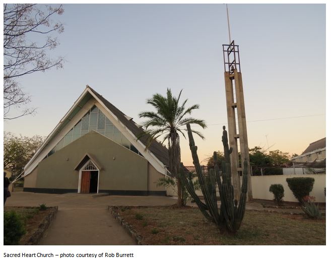
Other good schools in the area include Mzingwane High School, a government school with a good academic track record and on the Ncema river is the Sacred Heart Girls High School, which was founded and continues to be run by the Missionary Sisters Of The Precious Blood, who mainly came from Germany shortly after the second World War, and lay teachers. The school teaches academic subjects and also offers agricultural activities.
I am grateful to Rob Burrett who gave me the following information on the Sacred Heart Home which was founded in July 1946. Many young men came to Rhodesia to be trained as pilots for the RAF, the program was called the Rhodesia Air Training Group (RATG) They did elementary training on Tiger Moth’s and Cornell’s at Induna air station before moving on to the twin-engined Airspeed Oxford’s at Kumalo air station. Once they qualified, they were posted back to England for conversion onto multi-engined bombers such as the Halifax, Wellington and Lancaster.
Their posting to Rhodesia sometimes resulted in relationships with with women of all groups, Black, Coloured and White. The last were looked after by the state within the existing white children’s home system, but the Coloured children were left to unwanted and the Church stepped in to provide much needed support and relief. Father Sixtua Impler CMM often called “the Father of the Coloureds” and Bishop Arnoz CMM believed these offspring deserved a loving, stable upbringing which many of their abandoned mothers could not afford to provide.
They solicited funds from church congregations, the community and the authorities and the project started with the property now occupied by Sacred Heart being bought in 1946 and the Primary School opening in May 1947 to cater for the education of abandoned children, particularly coloured children. The Sacred Heart community slowly developed with Father Canisius Pfingstmann CMM arriving as resident chaplain in 1949; in the same year Brother Athanasius Sattich CMM erected the first substantial buildings which included two dining rooms, the kitchen, and adjacent laundry.
Sacred Heart Home was officially opened on 8th September 1949 by His Lordship Bishop Arnoz CMM with the Chapel and Sisters’ accommodation being added the following year. In 1951 the Grotto of Our Lady was built, with the statue installed in May 1952.
The Secondary school for girls was added in 2012, although the home still caters for children from three weeks to thirteen years and the Primary and Secondary schools are staffed by the CPS sisters and lay teachers. In addition, Sacred Heart Home serves the local Catholic community and has several outstations.
The somewhat unusual church was blessed by Bishop A.G. Schmitt CMM on 27th November 1957; it has a steeply pitched roof that was erected before the body of the church and is separate from the walls. The heat resistant glass windows and steep roof ensure the building is always cool.
Between Sacred Heart and the Ncema River is an old building together with a Kaytor hut built up on a brick foundation and surrounded by Syringa trees (Melia azedarach)
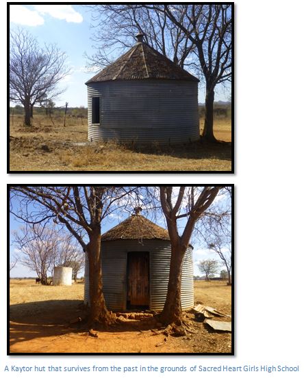
There are broken walls and foundations in the vicinity of the Kaytor hut, so perhaps this was an old police camp, or post office, or used as mine housing. The Kaytor hut is a cylinder of corrugated iron of from twelve to eighteen feet (3.6 to 5.5 metres) in diameter, about eight feet high (2.4 metres) with casement windows and floors of stamped mud. They either have a thatched roof, or a corrugated iron roof, as in the case of the example above. The most characteristic feature is the little iron chimney topped off with a metal cone which acted as a ventilator and was rain-proof. Often two Kaytor huts were placed together and connected by a verandah. There are two good examples just outside the National Archives at Harare; I am told they are from the Mazowe Police Station.
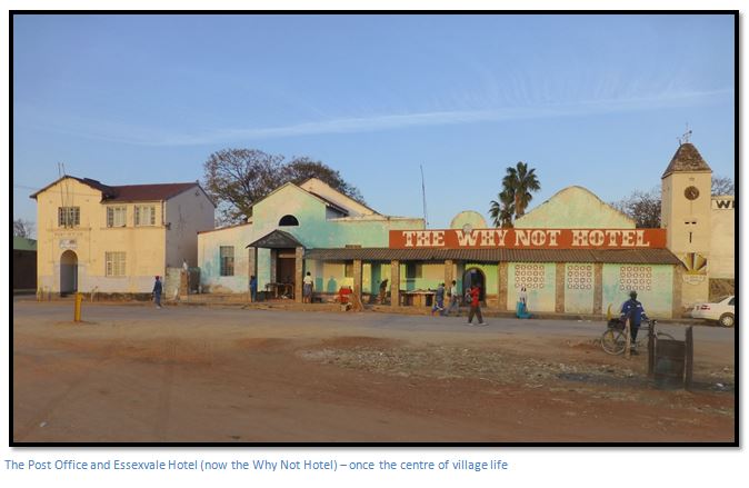
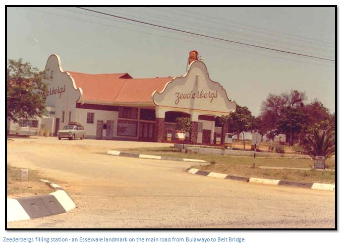
The 1969 census listed a population in Esigodini of 1,240 Africans, 105 Whites and 5 Asians and the village comprised a Petrol filling station, a hotel, butchery and small supermarket, Post office, Church, Police station and country club. The 1982 census listed a population of 1,492 but this number has grown hugely in recent years and there is considerable urban sprawl to the east and south of the original village.
Bulawayo receives its water supply from the Ncema dam which is situated on the Essexvale estate. Before the establishment of Essexvale as a township, the Administrative centre was at Mawabeni (then called Makukupen) which was opened as a police post in 1896 by H. M. Jackson, who later became a Chief Native Commissioner.
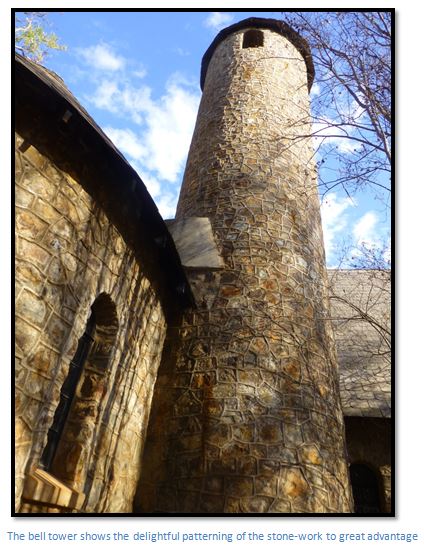
The Anglican Church of St Mary the Virgin is constructed of local stones cemented in place and was clearly the centre of a thriving community when the foundation stone was laid by Sir John Kennedy KCVO, KBE, CB, MC on 24th November 1951. The porch, so reminiscent of an English Parish Church where presumably so many of the parishioners originally came from has a roof on the west end, replicated on the east end above the chancel and altar, that is shaped very like a local pole and dhaka hut.
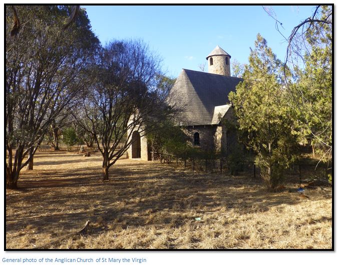
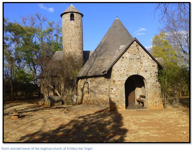
The little church, dominated by its stone bell tower, stands in the centre of Esigodini, its construction a great tribute to the congregation that worshipped in the little church and who financed its construction and to its builders as the exterior appears to be in excellent condition after more than 65 years.
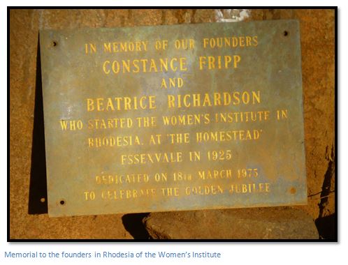
In the garden is a small memorial to Constance Fripp and Beatrice Richardson who started the Women’s Institute (the WI) in Rhodesia at “The Homestead” in 1925. The memorial plate just survives below a small bird bath feature in the garden.
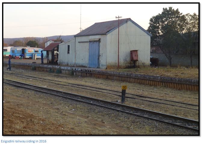
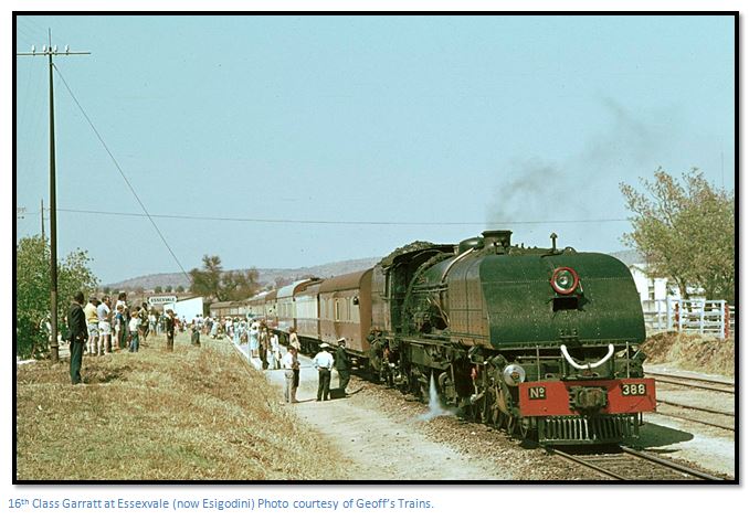
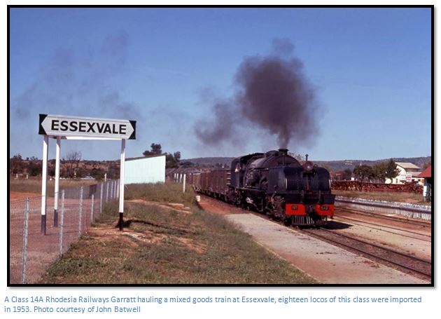
NRZ, the National Railways of Zimbabwe are now technically bankrupt and the rail movement on the Gwanda branch line to South Africa is carried out by contractors. A great pity as this was a favoured section for steam train enthusiasts who relished taking photos of the Class 16a Beyer-Garratt’s pulling their loads up the Mulungwane bank on the West Nicholson line.