Gweru (formerly called Gwelo)
Gweru lies on the main Harare – Bulawayo road (A5) 164 KM north-east of Bulawayo and 274 KM south-west of Harare.
The A17 connects Gweru to Mvuma from where the A4 connects with Masvingo and Beit Bridge. South from Gweru the A18 connects to Shurugwi and Zvishavane.
In pre-colonial times Gweru may have been one of the outposts of the Rozvi Empire and was almost certainly the site of a Matabele regiment’s kraal and outpost for Lobengula’s cattle east of the Somabhula forest.
In colonial times from 1894, Gwelo was supported by Dr Jameson, who thought it was well positioned as a future centre between Bulawayo and Salisbury (now Harare) At one time it was proposed to call the early settlement Jamestown, or Jamesontown, but the ill- fated Jameson Raid on Johannesburg in 1895-1896 ended this proposal. The town took on the Shona name of its stream Gweru, or as it was mispronounced, Gwelo, which is said to mean “steep sides” and comes from the Ndebele word ikwelo. The amaNdebele women in the area are supposed to have given the river this name as they could never find an easy place to climb once they had filled their water pots. In 1982 the name Gwelo was officially changed to Gweru.
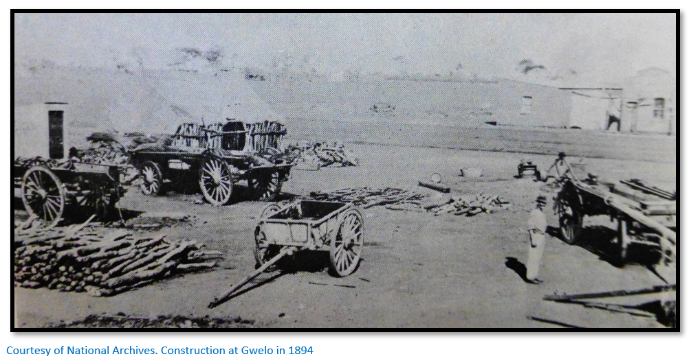
R.B. Nash arrived in Bulawayo in June 1894 and then moved to Gwelo. He said: “I took out an auctioneer’s licence, which was the first licence issued for the Gwelo township, and was supplied by the late Sir Melville Heyman, who was in charge of the office, a small tin building. I then engaged native carriers and walked through to Gwelo, only to find the town had not materialised, the Surveyor not even arrived. My capital consisted of half a bag of meal, three natives I had brought up with me from Barberton and £5 in cash. The outlook was not rosy.” Nash started the first newspaper The Northern Optimist in December 1894 on cyclostyled paper, but sold it to J. Harper after four months, who renamed the paper the Gwelo Times.
Frederick Burnham, the American Scout, with his brother-in-law Pearl Ingram claimed to be the first to survey and lay out the town in 1894, but some including Rob Burrett, have claimed it was done by Percy Brown, an early settler. The town was laid out on the high ground between the north side of the kopje and the Gwelo River with the broad avenues running north and south and the streets running east and west.
In this pioneer Gwelo village composed mostly of tents and wagons was born the first European baby, Thomas Edward Whitebeard, on 25th November 1894, his father being a mason-prospector. However David Hurrell was the first to be baptised! Gwelo was initially important as a coaching station on the Harare – Bulawayo route and had six hotels by 1895.
Gweru began slowly, but expanded as Fort Victoria (now Masvingo) lost impetus with transport into the country ceasing to come from the south and many of Fort Victoria’s early citizens eventually came to Gweru. Long-term Gweru owes its existence to the fact that it is situated along the Great Dyke. This is a roughly 500 kilometre long fault along which, to put it very simply, unimaginably hot magma pushed its way through the hardening crust of the earth. A large part of Zimbabwe’s wealth is based on the Great Dyke which contains many very valuable minerals and metals, including chrome, asbestos, platinum, gold and silver.
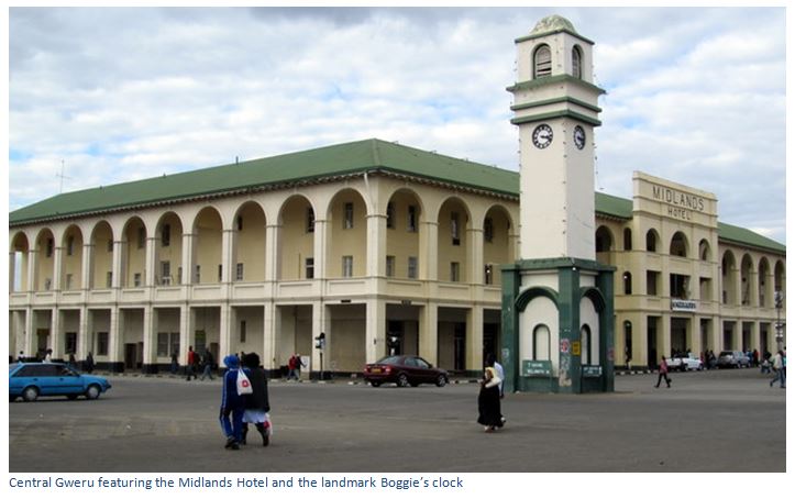
Although not many people lived in Gweru, it was in the focus of gold prospectors in the late nineteenth and early twentieth centuries with gold-mining to the north-west in the area called Mavene’s, around Shangani to the west and in the south-east in the Selukwe area (now Shurugwi) The miners used the town as their base buying supplies at the stores of Austin and Fotheringham and Peter Falk and staying at one of the four hotels; either the Horseshoe Hotel, the Victoria Hotel, the Gwelo Hotel or the Rolling Stone Hotel. Later Meikles Store opened its doors as a wood and iron structure.
Mr and Mrs Hurrell arrived in the country by ox-wagon in 1892 and farmed in Fort Victoria before leaving for Gweru. Mr Hurrell became the Zeederberg coach agent. “We had to put up stables for the mules and provide food and accommodation for the passengers, as the coaches arrived at all times, often during the night, especially in the wet weather; so we started the small hotel which eventually became the Horseshoe Hotel, where the Midlands Hotel stands today.” At first the hotel consisted only of a few pole and dhaka huts. “If the terrific rains of those days washed away the dhaka, the hotel natives had to hurry and plaster on some more.”
However in the early days the citizens of the town were not happy with the BSA Company. The telegraph line from Bulawayo had still not arrived and nothing had been done about health or sanitation, the boundaries of Matabeleland had not been settled and there was no Magistrate. Most mining claims were being registered in Bulawayo.
On 22nd March 1895 the Government offices were completely destroyed by fire and all the documents inside destroyed, for which the BSA Company were roundly condemned for using such an inadequate building. A town committee met Dr Jameson in his capacity as the country’s Administrator. He agreed to deepen the town’s well and source of water, to appoint a Magistrate, to erect a gaol and move the BSA police into town from their camp three miles out of town. A permanent Post Office would be built, additional supplies of slaughter cattle would be authorised and a cattle pound built, the BSA Company would recruit nursing staff for the small hospital.
Things improved when Captain Heyman came from Bulawayo and divided Matabeleland into the districts of Bulawayo, Belingwe and Gwelo and then the telegraph line arrived on 20th January 1895. A few ladies joined their husbands, the first billiard table was installed at the Victoria Hotel and Dr Hackett arrived as the town’s first doctor. Finally more substantial buildings were being erected of brick and the first hospital in two rooms was opened with Mrs Hurrell as Lady Superintendent. However, there was still no bank and miners had to travel to Bulawayo by coach to deposit their gold output until a Standard Bank was opened in 1896.
In 1895 – 1896 many settlers came from South Africa and with the moderate climate began cattle farming which is still an important activity to this day.
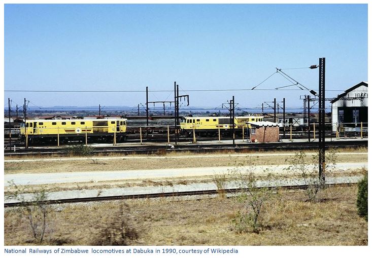
Later, in 1902 the cities of Bulawayo and Harare were connected by the railway that also came through Gweru and furthered the town’s prosperity. Today the town is a major rail communications centre with additional branch lines leading Shurugwi (formerly Selukwe) Masvingo (formerly Fort Victoria) Zvishavane (formerly Shabani) and Maputo in Mozambique and to South Africa via Beit Bridge. Dabuka a few kilometres west of Gweru has developed as a major railway marshalling yard and is the biggest container handling facility in the country.
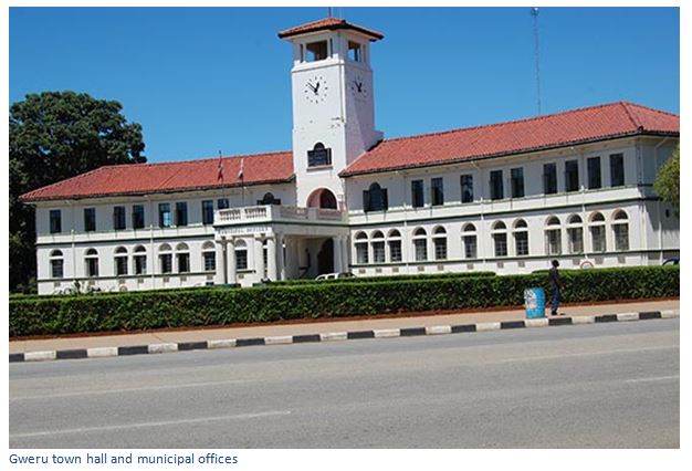
Gweru became a Municipality in 1914 and gained city status on 1 October 1971 and is today the third largest town in Zimbabwe. With its central location and water supplies from Amapongokwe, Whitewaters and Gwenoro Dams the town began to develop as an important industrial centre, employing over 26,000 people in the mid 1980’s. The country received a massive boost when it was selected as an Air Training Group along with Canada and Australia and South Africa to train aircrew for the Royal Air Force; JF MacDonald in the War History of Southern Rhodesia wrote that it was “undoubtedly Southern Rhodesia’s greatest single contribution to the Allied victory.” Southern Rhodesia was the last of the Commonwealth countries to enter the Empire Air Training Scheme (EATS) but the first to turn out fully qualified pilots and by size of total population, it was the largest training scheme. Eventually there were eleven operating aerodromes that required a huge national effort to build, maintain and staff – three were centred on Gweru, included Unit 26 at Guinea Fowl which was an Elementary Flying and Training Scheme (EFTS) using Tiger Moth’s and Cornell’s and Unit 22 at Thornhill which was a Service Flying and Training Scheme (SFTS) using Harvard’s and Units 24 and 29 at Moffat which was a Combined Air Observation School (CAOS) training navigators and air-gunners using Battle’s, Oxford’s and Anson’s.
After the war, the buildings at Moffat were used by the Bata Shoe Company for their boot and shoe factory, but other industries which sprung up, many based on the agricultural and mineral products produced in the area included tanning, a glass works and steel foundry, precision engineering, asbestos products, industrial gases, concrete products, milling and cereal manufacture.
Minerals produced in the region include gold, chrome, iron ore, asbestos, limestone, barites and lithium ores. A factory manufactures dairy products and some of the largest cattle sale pens in the country are located at Gweru
The town has a modern General Hospital with facilities to care for general, maternity and infectious diseases. It also has a well-developed educational infrastructure with a University, two teacher’s colleges, and many pre-school, primary and secondary schools.
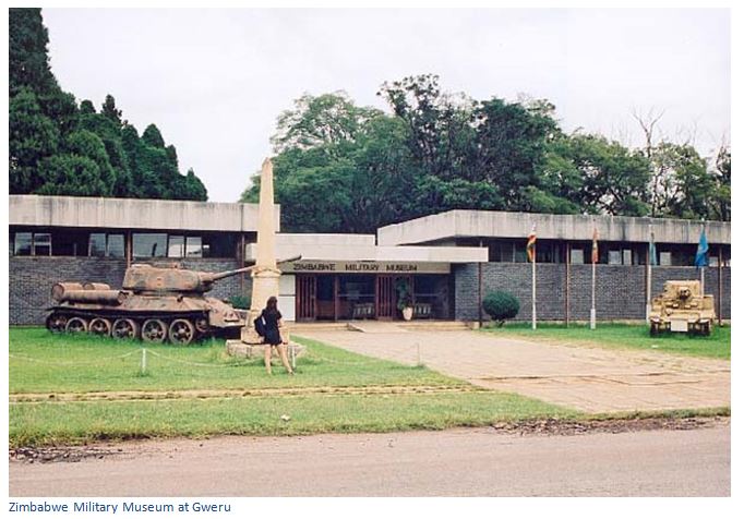
The Zimbabwe Military Museum is Zimbabwe’s army and aviation museum; of great interest to the international visitor are the several Great Zimbabwe-style Monuments that can be found between Gweru and Bulawayo, e.g. the Naletale, Danamombe and Zinjanja monuments.
A further and probably better-known attraction is Antelope Park, a lodge and game farm with a lion-breeding program and also Jabulani, south of Shangani.
Acknowledgements
P. Davies. The History of Gwelo, Part I. Rhodesiana No. 34, March 1976, P9-20