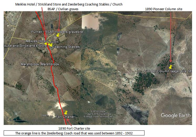
Fort Charter
Today it is hard to visualize the difficulties faced in 1890 by a tiny population of uneasily accepted newcomers to Zimbabwe who were isolated by many hundreds of kilometres of difficult and hazardous country from their supply base at Fort Tuli. Wet weather and flooded rivers often cut them off for weeks at a time; disease, especially horse-sickness and rinderpest killed their transport animals; plus there were the uncertainties of a local population, the Boers in the Transvaal Republic, and the Portuguese claiming Manicaland.
Fort Charter was one of the earliest forts to be established after those at Tuli and Fort Victoria (now Masvingo) Until 1897, the survival of the European population owed much to the establishment, during the 1890 occupation, subsequent 1893 Matabele War and later 1896-7 Rebellions, of some four dozen tiny, sandbagged forts carefully sited throughout the country. Fort Charter is one of the few surviving examples, although much neglected.
Lord Randolph Churchill in his account of Fort Charter written in 1891 was severely critical of its defences and notes that most of the BSAP Troopers manning the fort were sick with fever.
Fort Charter appears on all the early maps of the country, but despite its strategic location it was largely abandoned and the first Hotel was established for the Zeederberg coaching service a few kilometres to the north after the drift over the Ngesi River and was developed into Charter Estates by the Meikles Brothers.
Distances are from the Mupfure River (formerly Umfuli River) just south of Beatrice on the A4 National road going from Harare to Chivhu (formerly Enkeldoorn) At 28.6 KM take the gravel road to the left at a large “Sadzaguru” signpost. The GPS reference is 18⁰30′44.39″S 30⁰53′05.74″E Keep to this road which is in good condition. At 41.8 KM cross a spruit and turn left in front of the farmhouse, 48.8 KM reach a T junction and turn right, 49.2 KM turn left onto a gravel road marked to Marondera and Charter Primary School, 50.9 KM turn right at the signpost “Sadzaguru” onto the farm entrance road (formerly Charter Estates) 51.2 KM pass Church on right, 51.25 KM turn right and follow farm track, 51.4 KM arrive at the old tractor shed with open sides and corrugated roof. Now a community centre, follow the track to the left of the building and then bear right on the gravel track, before heading south. 52.3 KM cross the small stream, a tributary of the Ngezi River; 52.7 KM continue straight at intersection, the gravel road starts to improve. 53.1 KM turn left onto a smaller gravel track travelling southeast, 55.7 KM park car. Fort Charter is 100 metres away on the left; the granite plinth is the most distinctive feature.
For the return journey retrace the same route as the quickest way to get back to the A4.
GPS reference for Fort Charter: 18⁰35′32.03″S 31⁰03′47.56″E
GPS reference for 1890 Pioneer Column laager site: 18⁰34′07.94″S 31⁰07′00.99″E
Introduction
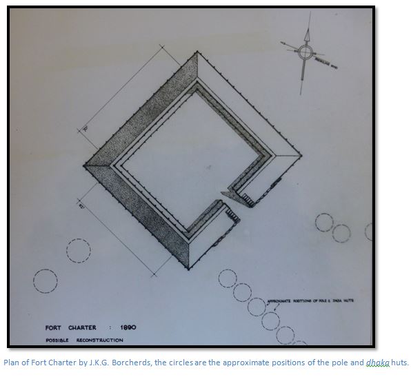
This paper is based on a survey carried out by J.K.G. Borcherds, B.Arch., RIBA in September 1960 in which he drew the architectural sketches below and made some preliminary explanations on Fort Charter and other buildings on Marshbrook Farm . The paper and sketches are filed in the National Archives
On 13th May 1990, David Worthington and Cormac Lloyd each gave a talk to the Mashonaland Branch of the Society at Fort Charter and their texts were published in Heritage of Zimbabwe Publications No 10 and 11.
I am very grateful to Tony Mirams, the last General Manager of Charter, and his son Craig who lent me copies of J.K.G. Borcherds’ article and drawings and accompanied me to Charter Estate.
A separate article covers the buildings on Charter Estates – the Old Meikles Hotel, the Mill and Coach House and Coaching Stables, which served the Zeederberg Coach, and Strickland’s Store and also the civilian and BSAP graves.
Fort Charter – General
Fort Charter was one of three line-of-communications forts established by the Pioneer Column in 1890 between Camp Macloutsie and Fort Salisbury; the two others being Fort Tuli and Fort Victoria. The Fort lies on the Zeederberg coach road about 110 kilometres south of Salisbury, at an elevation of 1,430 metres, in slightly undulating grass veld with scattered Muhacha (Parinari curatellifolia Planch. ex Benth) on the ridges and Msasa belts (Brachystegia spiciformis) in the river valleys.
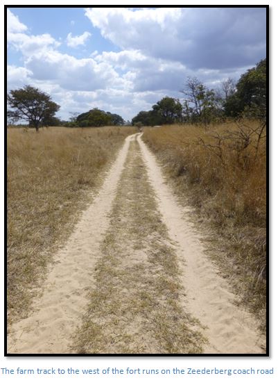
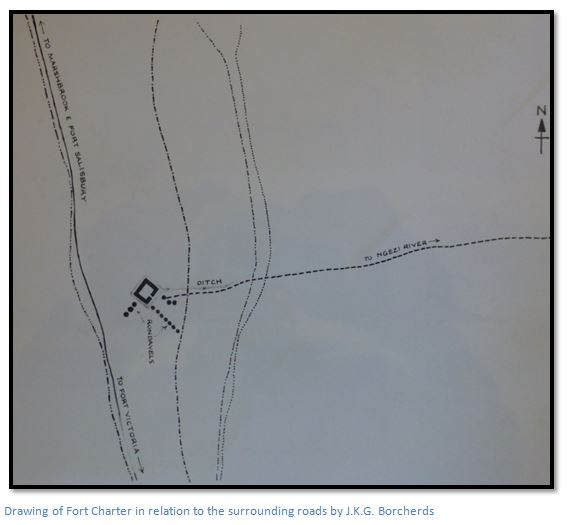
The Fort commands a gentle ridge which slopes down to a small spruit to the west and towards the Ngezi River, about 800 metres to the east. Lord Churchill said this had water all year round, which was presumably one of the main reasons for choosing this site. However, the site is swept by a prevailing wind which blows from the south-east and can be very cold in the winter months. The existing farm road follows the old coach road that connects Fort Charter to the Charter Estate complex about 4 kilometres to the north.
Charter owes its importance to its location at the intersection of the Fort Victoria (Masvingo) – Salisbury (Harare) road and the road that ran east-west from old Marandellas, where Ruzawi School is today, to Iron Mine Hill, Gwelo (Gweru) and ultimately Bulawayo.
Historical
The Pioneer Column’s Routine Orders for the 3rd September 1890, state that on the following day a site was to be indicated to Capt. M. Heyman, O.C. A Troop, BSAP, for a fort to be erected and to be garrisoned by the troop under his command. [See Appendix A] The site was named “Fort Charter” in recognition of the Royal Charter under which the Pioneer Column operated.
Fort Charter is sited a little over 6 KM south west of the Pioneer Column laager site which was located on slightly higher ground forming the watershed for the area. Nearby are located the headstreams of both the Ngezi and Sabi Rivers, indeed, the farm Sabi Oog; Afrikaans for “Sabi eye” is just a few metres from the laager site.
Henry Francis “Skipper” Hoste was one of the older officers when he was commissioned at 37 as a Captain of B Troop in the Pioneer Corps. He kept a diary which was published a few years before his death in 1936 called An Account of Forty Years Ago: Rhodesia in 1890.
“On September 2nd we were laagered on the headwaters of the Umniati River. The following day was the coldest of the whole trip: it was blowing a hard easterly gale, accompanied by showers of icy cold rain. We who were ahead were trying to reach a place that had been christened Mooi Fontein [sweet spring] by van Rooyen, a celebrated hunter. Ted Burnett was with us, he was careful to explain that although the Fontein was there all right, he had never been able to discover where Mooi came from.
We reached the place just before sunset, and Burnett was proved to be quite right. It was a beast of a place to come in on a cold night. There was not a scrap of shelter as far as could be seen. I sent two or three parties to prospect around for a place of some sort where we could camp for the night with some modicum of comfort. Presently a man came back and said he had discovered a few skimpy bushes that might give a little shelter, so we shifted over to them. They did not amount to much, so we turned to and dug some trenches to sleep in. It was easy work digging as the soil was mostly sand. We made them about two feet deep and as we threw up all the soil we dug out onto the weather side, we were fairly well sheltered from the wind and passed a comfortable night after all. The column turned up at dawn and laagered near us.
We stayed there on September 3rd, partly to give the cattle a rest and partly to select and mark out a place to build a fort, which was to be called Fort Charter. A Troop (Police) was left behind to build a fort and garrison it.”
It was here that A.R. Colquhoun, the first Administrator of Mashonaland, left the Column for Chief Umtasa’s kraal, to deal with a threatened Portuguese incursion. He was accompanied by the Column guide, Capt. F.C. Selous and Lieut. A. Campbell.
The Pioneer Column continued northwards, under the guidance of Capt. A.E. Burnett, to establish the final fort, the site of which was reached on the 12th September 1890, and named after Lord Salisbury.
On the 31st October 1890, “A” Troop left Fort Charter under orders to proceed to Manica and they were not replaced by “D” Troop until the 2nd February, 1891. After being garrisoned by a small BSAP force in 1891, Fort Charter fell into disuse and was not manned as a Police station again until 1896.
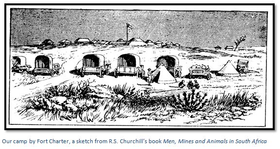
In April 1891 Lord Randolph Churchill, who was a shareholder in the Charter Company decided to visit Mashonaland and being sceptical of the rich gold claims, took with him a well-known mining engineer, Henry Perkins. The daily Graphic paid him £100 for each letter printed of which the following is an excerpt. “As the year was getting on…it was decided that I should go ahead of the wagons to Fort Salisbury (now Harare)… from Fort Victoria. A dreary and tedious journey is the one designated under the heading of this chapter. Five days and a half were occupied in getting over the distance of 125 miles to Fort Charter…The plain is an endless and most wearisome tract of barren sand, covered with dry, coarse grass, with stunted trees and bushes. Almost the whole way the road lies through heavy sand, in which passing wagons have worn deep ruts and on which the animals obtain no firm foothold… The vast tract of land between Fort Victoria and Fort Charter is unsuitable and grievous for man, or for domestic beast …About five miles south of Fort Charter I met Mr Colquhoun, the chief civil administrator of Mashonaland…he seemed sanguine as to the future of the country. The gold findings on the Umfuli River, near Hartley Hill, he told me were expected to turn out of great excellence, and he had favourable reports about the prospecting on the Mazoe River. Fort Salisbury, he added, was becoming quite a township, with a regular street of huts and tents, possessing two auctioneers.
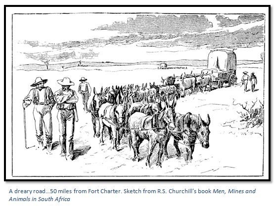
We reached Fort Charter on the following morning, the 12th August. Within half-a-mile flows a rivulet containing a fair amount of tolerable water at all seasons of the year. Both Fort Charter and Fort Victoria appeared to be miserably weak constructions, which a few thousand Matabele would probably rush with ease, attacking as is their habit, in the dark just before daybreak. There is nothing to stop the rush of the savage foe, save a ditch from three to four feet deep, a mound from ten to twelve feet high from the bottom of the ditch and two or three strands of barbed wire stretched on weak posts. The officers of the police evidently disdain the Matabele, and have perfect confidence in their Martini-Henry rifles and their Maxim gun…The precaution of sinking a well, either within or close by the Fort has been taken neither here, nor at Fort Victoria, nor at Fort Salisbury. Surely this neglect is imprudent? The garrison of Fort Charter consisted of a lieutenant and twelve troopers, of whom ten were sick with various ailments. For three months during last rainy season a force of over sixty men at Fort Charter, with many sick, saw no doctor.”
In 1891 Lobengula sent an Impi who killed Chief Lomagundi for his refusal to recognize amaNdebele supremacy, or pay his tribute. Lobengula’s policy was to avoid any collision with the BSA Company without abandoning his authority over the Shona, but this meant walking a very fine line. Jameson prevented prospectors from looking for gold reefs and traders from entering Matabeland without seeking Lobengula’s permission, and Lobengula’s Impis were under strict orders not to molest white settlers. In 1892 further raids took place within the Victoria District and the general situation in Mashonaland continued to be unsettled.
In July 1893 an amaNdebele Impi of about 2,500 fighting men came up to Fort Victoria and began killing Mashona and entered the town, killing the servant of the Anglican Chaplain. Women and children came into the town for protection and about 400 local men enrolled as volunteers. On 17th July 1893 a clash with the amaNdebele took place outside Fort Victoria when Capt. C.F. Lendy, the magistrate, led a small force of 40 to 50 mounted police and volunteers in a fight against the amaNdebele which resulted in Umgandan, the second in command and a dozen others being killed.
On the 19th July, Major Patrick W. Forbes met with Jameson who had decided to mount an invading force to once and for all break the power of the amaNdebele. Volunteers were promised:
(1) Protection of all mining claims in Mashonaland until six months after the war finished,
(2) A farm of 3,000 morgen (6,351 acres) free of occupation and
(3) Twenty gold claims and
(4) A share of all the cattle taken; 50% to the BSA Company; the other half to be divided amongst all the volunteers equally.
There followed an uneasy peace of eleven weeks, before on the 5th October 1893, Sir Henry Loch, the High Commissioner, gave Jameson permission to advance into Matabeland with the forces of the BSA Company, and for Lieut.-Col. Hamilton Goold Adams to march from the base at Macloutsie towards Bulawayo with his force, the Bechuanaland Border Police and an equal number of BSA troops led by Commandant Raaff.
Salisbury column - Salisbury (Harare) - Fort Charter - Iron Mine Hill | ||||
Tues | 28 | Aug |
| Advance party under Capt. Finch leaves for Fort Charter |
Tues | 5 | Sept |
| Column under Major Forbes leaves Salisbury |
Wed | 6 | Sept |
| Cross Hunyani River (Manyame) at daybreak |
Thurs | 7 | Sept |
| continue |
Fri | 8 | Sept |
| Cross Umfuli River (Mupfure) and laager |
Sun | 10 | Sept |
| reach Fort Charter |
Sat | 30 | Sept |
| Jameson and Sir John Willoughby visit Fort Charter |
Mon | 2 | Oct |
| Column leaves Fort Charter to first water |
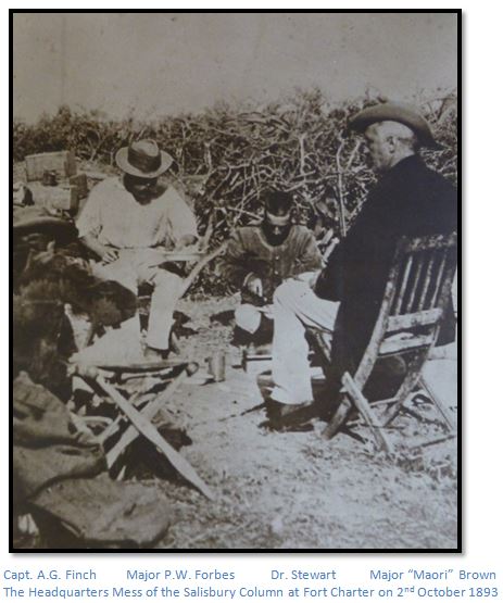
For a fuller account of this action read the article Iron Mine Hill (Ntabasinsimbe) and the first casualty of the 1893 Matabele War under Midland Province on the website www.zimfieldguide.com Over 1,000 horses were purchased by Commandant Raaff in South Africa and it was decided they should be met at Fort Charter, instead of Salisbury. On the 28th August 1893, Capt. Alan G. Finch left to meet the horses at Charter and get the camp ready with five others, including two farriers and three wagons carrying all the saddlery.
The earliest date given by Jameson for the horses to arrive was the 15th September; so the Salisbury column left by foot in the afternoon of Tuesday 5th September for six-mile spruit. Next day they crossed the Hunyani River (now the Manyame) by double spanning the wagons and travelled about 10 kilometres. On Thursday they did about 19 kilometres and Friday the same, laagering on the Umfuli River (now the Mupfure) On Saturday the column did 8 kilometres in the morning, but encountered heavy sand thereafter, which knocked up the oxen, and only managed another 8 kilometres getting into camp after dark. On Sunday 10th September, the column arrived just before dark on Marshbrook Farm and laagered on the north bank of the stream.
On Monday the force moved over to the south bank of the stream, about 800 metres south of the Charter Estates buildings and 3 kilometres north of Fort Charter itself. Only 59 horses had arrived and many were in poor condition. The camp comprised the sixteen wagons with “A”, “B” and “C” Troops in rough shelters outside, with the dismounted Troop and Artillery within the laager. As 50 horses were required for a Troop, they took mounted drill in turns and practised skirmishing, picket duty and rifle drill. On the 22nd September another 109 horses arrived and fitting and altering the saddlery for the three Troops kept everyone busy.
Jameson had been checking that the Tuli column was ready to start, but drove up to Fort Charter in a post-cart accompanied by Sir John Willoughby. The whole force marched past Jameson, before the mounted troops cantered past advancing in line and doing some skirmishing. At an evening smoking concert Jameson expressed himself pleased with the result and advised that the Salisbury column would leave Charter and move forward slowly to give the Victoria column a chance to rendezvous at Iron Mine Hill.
The column’s strength on leaving Charter on Monday 2nd October 1893 was whites 258; locals 115; horses 242.
The Salisbury and the Victoria columns joined together just west of Iron Mine Hill, south of Lalapanzi, and were under the command of Major Patrick Forbes. After fighting two pitched battles at Shangani and Bembezi they took occupation of Bulawayo on 4th November 1893
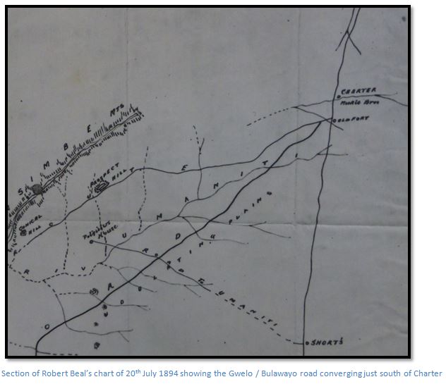
From the 1894 chart section above, it can be seen that the main road passed to the west of the fort, as does the farm track today. Meikles Hotel and Strickland’s Store are situated four kilometres north with the Mill and Zeederberg’s Coach House and Coaching Stables. Rhodesia’s Pioneer Women 1859 – 1896 compiled by Jessie M. Lloyd confirms that Mrs Strickland, née Jeannie V. G. Meikle, the eldest of the well-known Meikle family, trekked up with her husband Arthur from Natal and lived their first years at Charter. Sometime after 1896 they moved to “Inodzi” near Penhalonga, where they remained until Mrs. Strickland’s death in 1957; but the store was called Strickland’s Store for many years thereafter.
1896 Mashona Rebellion or First Chimurenga
Some years later on June 15th 1896, the first Europeans were killed at the start of First Chimurenga, or Mashona Rebellion. As news of the killings spread the farmers in the district formed a laager around the buildings comprising the Hotel and Store, the Mill and Coach House and Coaching Stables. Fort Charter was not suitable for civilians and was not used as a laager at this time, but appears to have been garrisoned by August / September 1896. Provisions were scarce and food was rationed, the cattle dead from rinderpest. However, ammunition arrived from Fort Victoria and the garrison patrolled with the seven remaining horses.
This newspaper account from the Rhodesia Herald of Wednesday 16th July 1896 was written by Dan Judson. “The Salisbury Column arrived at Charter at 2pm yesterday and laagered up close to Strickland’s store. This has now been converted into a most snug little laager, the work carried out reflecting the greatest credit on all concerned, and especially Firm and Strickland. Outside the wagons is a close pole stockade with a high back and deep ditch filled with broken glass and crossed by a drawbridge on the outside. It is garrisoned by 35 white men, 30 Cape boys, and there is ample room inside for these and the 12 women, 15 children, and 10 horses requiring protection. It has rations for six weeks and plenty of ammunition. Its defenders are in the best of spirits and only anxious to get outside to attack the natives. No fears need be entertained as to the safety of the place, which is without question one of the most important posts in the country. After loading up fresh supplies of grain, the column left at daybreak this morning, and is now laagered six miles from the Umfuli, which will be crossed tomorrow morning. After our column left, Captains Brabant and White’s column arrived. They had burnt about ten of Umtegeza’s kraals, but had not been successful in meeting with any natives, who are believed to have fled towards the Sabi and Mount Wedza.”
Lt.-Col. E.A.H. Alderson, the Commanding Officer of the Mounted Infantry who had travelled from Cape Town by sea to Beira, then by rail to Chimoio, and the remaining distance to Umtali and then Marandellas by ox-wagon and horseback, had been appointed in charge of the entire Mashonaland Field Force. Local forces had been very active in patrolling the countryside outside Salisbury and bringing in sieged parties from Mazowe and the Abercorn Store and other isolated places.
After the Mounted Infantry arrived at Salisbury on the 25th August, and the local volunteer forces were reorganized; Major A.V. Jenner left the base at Nursery Farm near Newlands on the 1st September for Chief Umtegeza’s kraal, about fifty kilometres south of Fort Charter, via Marandellas and Fort Charter. The main force hoped to meet a resupply food convoy enroute; whilst the Natal Troop went direct to Fort Charter where they had only five day’s rations.
On arrival at Charter, Jenner states they found the Natal Troop, but little else, and he describes Fort Charter itself as having; “the appearance of a gypsy encampment, just before being told to move on by the local police….It possessed a telegraph office, in which I passed many hours of mutual recrimination (by telegraph) with the civil officer at Salisbury, whose duty it was to see that every available and other waggon was free to carry supplies to Salisbury.”
1899 – 1902 Boer War
The Anglo-South African, or Boer War, raged from 1899 to 1902 and Rhodesia (now Zimbabwe) played a full part in the fighting, with the Rhodesia Regiment and the BSAP both at Mafeking and along the border of the Bechuanaland Protectorate (now Botswana) This movement of troops to the south happened only a few years after the Matabele (First Umvukela) and Mashona (first Chimurenga) uprisings of 1896-7; so due to local concerns, a number of troops from Australia and New Zealand were diverted through Beira.
The Rhodesian Field Force (RFF) as it was called under the command of Lieut.-General Sir Frederick Carrington faced tremendous logistical challenges. The railway line from Beira to Umtali had been opened on 4 February 1898, but only in 2ft gauge, and in 1900 was being converted to 3ft 6inch gauge. The railway line from Umtali to Salisbury had been built as 3ft 6inch gauge and opened on 23 May 1899; Salisbury and Bulawayo was still unconnected by rail.
In 1900 to get soldiers from Marondera to Bulawayo, they travelled either by Zeederberg coach if they were officers, or by ox-wagon and foot, if they were other ranks. They travelled through Fort Charter, Enkeldoorn (now Chivhu) Umvuma (now Mvuma) Iron Mine Hill, Gwelo (now Gweru) and then Bulawayo; the slower journey by ox-wagon taking up to 25 days. Several thousand troops must have passed through Fort Charter at this time. There is no evidence for any Australian or New Zealander graves at Fort Charter and for further information read the article: Anglo Boer War graves at Paradise Plot Cemetery, Marondera on the website www.zimfieldguide.com under Mashonaland East Province.
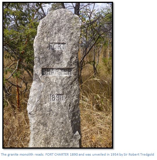
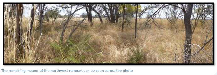
David Worthington says the granite obelisk inscribed “Fort Charter 1890” was erected on the north-west rampart through the efforts of Sir John Noble Kennedy, who was Governor of Southern Rhodesia from 1947 to 1953 and Cormac Lloyd states it was unveiled in 1954 by Sir Robert Tredgold.
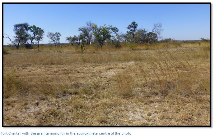
The fort now lies deserted; the walls have collapsed from the effects of over a century of rains and the hooves of grazing cattle as the site was never fenced.
Fort Charter’s existing remains
These consist of the much weathered walls forming a rectangle which now rises barely a metre above the surrounding ground level. They are surrounded by a ditch now largely filled-in and 0.75 metre deep at its lowest, with the whole complex (on the outside) measuring about 40 metres x 43 metres. A drain leads from the eastern side towards the Ngezi River. The ditch appears to be a later addition as the original photos taken in October 1890, and shown below by Ellerton-Fry, show no ditch although the walls are intact.
In the early 1960’s a few pieces of hut dhaka with the imprint of poles was visible, but on our visit in 2016, I could find no traces left of hut remains, although it is possible that some of the trees now growing in the fort come from the poles that were used and have taken root.
Road remains
The map shows the whole area is laced with tracks. Those that run north and south are the remains of the Zeederberg coaching road. The heavy wagon wheels dug deep ruts into the soft, sandy soil so that following wagons would take a new track where the going was easier, resulting in numerous parallel tracks. They are visible on the ground as slight depressions with a strong growth of grass. The Pioneer Column road lay directly on the watershed about 5.5 kilometres to the east and reference has already been made to the Pioneer Column laager site 6 kilometres northeast of Fort Charter at 18⁰34′07.94″S 31⁰07′00.99″E.
A faint track leads south east from the fort 850 metres towards the Ngezi River which is the nearest available water and would have been used daily by a water cart. The Ngezi River has a much eroded ford and the track continues east. Another track leads northwest from the fort to a small spruit.
Malaria was rife at the site and when D Troop of the BSAP arrived in November 1890 during the rains, there were eighty men down with malaria overcrowding the pole and dhaka huts.
Dudley Gisborne who travelled through on the way to Salisbury in July 1892 says there was still a small garrison stationed at Fort Charter.
Reconstruction of Fort Charter
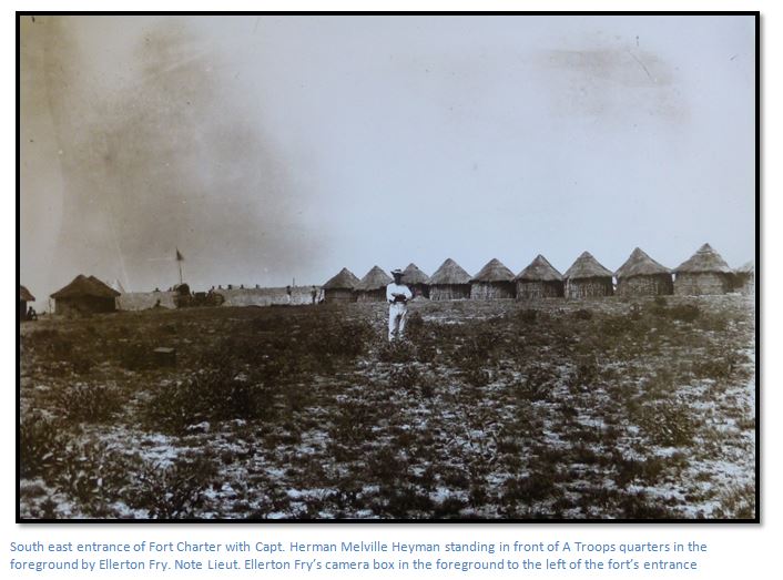
The main evidence for any reconstruction lies in the existing remains and the photos taken at the time by Lieut. Ellerton Fry, one of the Intelligence Officers to the Pioneer Column.
A Troop of the BSA Company Police were given the task of constructing the fort under the command of Capt. Herman Melville Heyman, one of the most competent officers in the Pioneer Column; also seen in one of Ellerton-Fry’s photos below.
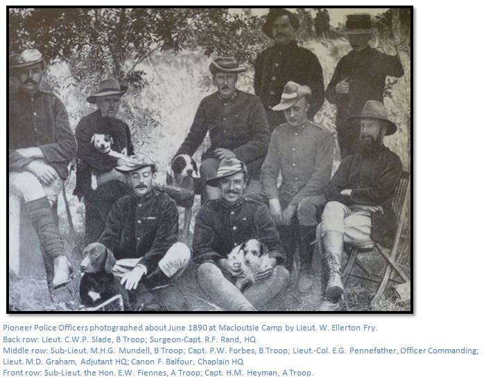
Lieut. M.D. Graham features in the text that follows in Appendix B with a letter describing Fort Charter to his mother, and Capt. H.M. Heyman commanded A Troop of the BSAP who built Fort Charter.
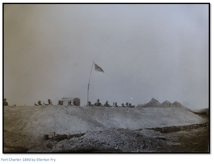
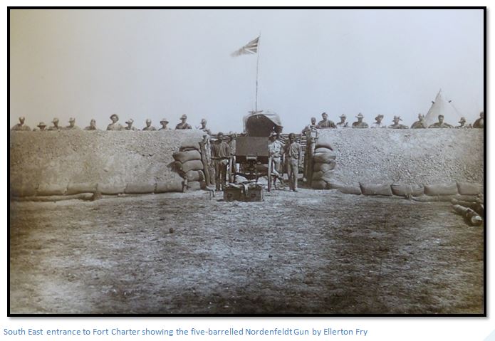
Fort construction was largely standardised, the typical fort internally being a square enclosure of 335 square metres. The outer walls were some 1.5 metres high (5 feet) and supported on their vertical inner face by closely spaced, rough-cut timber poles, braced and cross-braced, they were pierced by a single entrance. Round the inside ran a 0.6 metre wide firing step (2 feet) and externally the wall face sloped down to a 1.5 metre wide (5 feet) 0.9 metre deep (3 feet) dry ditch. This ditch provided the material for the walls and additional protection, but posed a serious health problem if allowed to contain water. It was often omitted, particularly at poorly drained sites, such as Fort Charter. The base of the outer wall was normally revetted with stone, if available, or timber or sandbags, and the wall topped by sandbags.
Inside, there was usually only a sun-dried brick store roofed with corrugated iron. Outside, but under cover of the fort, a double line of pole and dhaka huts housed the garrison. Wagons, mess-huts, telegraphist and hospital were also outside the fort, as it was never expected that the forts would have to resist prolonged direct attack. A fort represented a show of force, a stronghold only to be occupied as a last resort. The normal garrison of a fort was 50 men, with a dozen horses and a Maxim gun, but by 1891 the Fort Charter garrison had been reduced to a Lieutenant and twelve BSAP Troopers.
The photos show that the original fort did not have an encircling ditch which raises a number of questions. The ramparts would have required about 570 cubic yards of soil (about 250 wagon loads) for their construction, so why was the usual method of digging a ditch not used? If the soil was imported, where is the quarry?
The most obvious reason for importing soil would be because the local material for the ramparts was unsuitable. A sample of the rampart’s soil was examined by the Geological Survey in 1960 who found feldspar, ferruginous quartz, haematite, limonite and granitic rock in the form of pebbly gravel mixed with sandy clay. This is the common soil underlay in the area and can be seen often outside antbear holes. It seems unlikely that the soil was taken from the bed of the Ngezi River, there are no obvious pits in the vicinity of the fort and the soil was not taken from the forts interior.
The Ngezi River’s banks were examined; but all samples taken showed grey clay with little pebbly gravel. A small donga to the north of the drift did produce soil similar to the ramparts, but was too small to have supplied the quantities of gravel required, and wagon tracks were not visible. It is possible the gravel was sourced from the spruit to the west of the fort.
The first of the above Ellerton Fry photos indicate that the fort was supported by a timber stockade on the interior and on the exterior with sandbags around the entrance. The original author of this article, J.K.G. Borcherds, calculated the natural angle of sandy gravel to be 27⁰. A section through the ramparts is shown below with the interior height and width of the parapet top being deduced from the figures in Ellerton Fry’s photos. In 1890-1, the first year of the fort’s occupation, torrential rain turned the interior into a muddy quagmire.
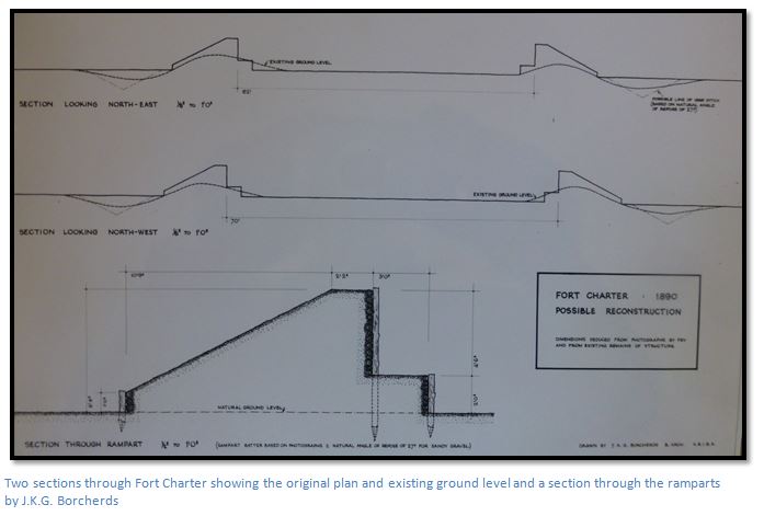
The original dimensions may also have been changed in 1896 when the fort was renovated; internally the fort was only 17 metres x 20 metres.
There are no remaining signs of the original pole and dhaka huts despite a search, and no rubbish dumps have been located.
Appendix A
Extract from the Regimental Order Book of the Pioneer Corps. Pages 173/174
Inlying Picquet BSACP
Rear Guards BSACP
Flanking Patrols BSACP
Advance Guards Pioneers
Reveille 4:30am
Col. will march Daylight
Sir J. Willoughby S.O.
Signed: Henry J. Borrow Lieut. and Adj. P. Corps.
Regimental orders by Maj. Johnson Comdt.
3rd September 1890
Rgt Orderly Officer 4/9/90 Lt. Mandy
In Waiting for the 5/9/90 Lt. Biscoe
I. Native Donty was this day brought before the D. Comdt. Charged with losing horses & fined 5/-
II. No 74 Gd A. McColl was this day sentenced to 3 extra Waterguards and fined £1 for being asleep on Waterguard on the 1 Sept. 90.
III. Lt. G. Burnett will act as Transport Officer from this date during the absence of Capt. Burnett (on duty)
The following Col. Orders are published for general information
Details
Capt. of the day Capt. Hoste
Inlying Picquet Pioneers
Col will halt Tomorrow
1. Night Picquets until further orders will consist of 4 Picquets; each composed of one NCO and three men.
2. A Troop Police will take over the Gardner gun and ammunition from the Pioneers at 7:30am tomorrow.
3. A Troop BSAP will move at 8am tomorrow for a site for a fort which will be subsequently pointed out.
4. Native Driver Dick was fined 20/- on the 20th August for allowing cattle to stray.
Signed: Henry J. Borrow Lieut. and Adj. P. Corps.
Appendix B
A letter written by Lieut. (later Colonel) M. D. Graham to his mother
Fort Charter 6/9/90
My Dearest Mater,
Imagine the Cape flats, only a good deal more of them and no town to speak of – 3 patches of scrub of sorts only – and the whole covered by tufts of grass with the finish of fine white sand all over and you have the country. 135 miles from Fort Victoria, altitude 4900 – then it was thought time to establish another Fort and accordingly “A” troop has been left in possession. There are 3 separate streams of water – all excellent. A permanent south Easter is the main objection, Mount Wedza is about 14 miles due east of us. We have not the Latitude and Longitude yet. 18.23 Lat: 30.32 Long is not far out. In case you compare this with Caustens map you will not find it tally at all. This part of the country according to him is 45 miles more to the East. So really we are that amount more West than he makes us. This place is bound to be healthy, though uncomfortable;…..The one redeeming feature is the game – all sorts of buck and antelope in abundance. Yesterday I started off to see if I could find some kraals which we heard were to the East / they want rations to build huts as we have no tents. I shot a steinbuck before I had left 10 minutes – about 2 miles further on I spotted two fine ostriches about ½ mile to the left feeding leisurely. I did not want to waste time, so did not go after them hoping to see them on returning; but it was too dark then. Further on I came on a troop of Hartebeest, but I did not try to get one as I had no means of bringing it in had I shot one. I should like Greenam here very much – twenty for a zesh if nothing else. But it is not my fate, I have to start off as soon as I can and survey the ground destined for the farms of the men of the Pioneer force when disbanded. It is a very nasty job. The Hunyane, Umfuli, Sabi and Masheke Rivers are the 4 corners, 25 miles by 30. That piece has to be surveyed and then cut up into 162 farms of 3,000 acres each. Not only cut up into farms, but actually beaconed off. It means about a month’s work in building beacons alone. One Ross, a nephew of the Administrator is to assist me and I applied for a man named Taylor of Pioneers – he is a bit of a surveyor and what is more has a theodolite. I have sent them on to wait for me at the Umfuli River (17 miles on) and shall follow them tomorrow, or next day. I would have left yesterday, only I thought I might first wait for the mail. The Post riders came in about 11 last night and I got letters of 14th August from you.
The Colonel and the Administrator know absolutely nothing about trigonmetrical surveying and imagine that we will finish the survey in about a month. 30,000 acres is one man’s work for a year according to Frome and we have 486,400 to account for! But of course the country here is very easy and there are no details except water to put in, don’t be surprised if you do not hear for a few mails. I don’t know where the Mount Hampden Road goes after leaving this. If it passes through the piece we have to survey I shall be able to catch the Post riders each week. I am taking 30 days rations to start with and shall draw more either from this place, or Mt Hampden according to which we are nearest. It will be dreary work and simply means riding about with a blanket and 2 days rations and working as one goes along, though we must get it done somehow. I am …£1 ….per diem while employed as the surveyor. It is not worth that, too monotonous by far.
My pony is dead – horse sickness. It is disgusting. He was a fully shaped pony, though his colour …him. Pale strawberry, white face and legs and no tail to speak of, 3 hairs on each side and one in the middle! I am so sorry to lose him. The truth …is strong enough, but exceedingly rough.
The wind here is awful. My present Chateau consists of a deep hole dug in the sand and covered over with a waggon sail, very snug too as long as the rain keeps off. That young Graham Jane mentioned I posted to this Troop at Macloutsie. But he was left behind in hospital when we came, with fever, a nice boy.
Willoughby goes home on 6 months leave as soon after reaching Mount Hampden as possible – some lawsuit. When this survey is over, I shall reappear as Staff Officer. If he turns up at the “Maim” (?) be civil to him even though he is such a little ….his fault. That stamp album…points with Bob – put on a high price and choke him!
I heard from Keith Falconer, he says he had two days rain. If the rain is commencing in the low country, goodbye to nosh and grub ‘til next May. We have six months rations here and 2 months …. That can’t last 7 months.
The Column reached here on Wednesday morning and remained until Friday afternoon, Mount Hampden is about 60 miles on they say. The waggon with our first newspaper mail is within 130 miles of us now. It will be a treat to get something to read. If there is anything interesting at times, it will reach us by post if registered. This tip sub rosa.
Acknowledgements
J.K.G. Borcherds, “A Brief Description of Fort Charter”, September 1960. BO 9/1/1 National Archives, Harare.
Tony Mirams for photos, letters and surveys
D.K. Worthington. Early Days at Charter Estate. Heritage of Zimbabwe Publication No 10, 1991. Pages 93-98.
C. Lloyd. Fort Charter. Heritage of Zimbabwe Publication No 11, 1992. Pages 123-130.
Lord R.S. Churchill. Men, Mines and Animals in South Africa. Books of Rhodesia Vol. 7, Bulawayo. October 1969.
P.B.S. Wrey in W.A. Wills and L.T. Collingridge. The Downfall of Lobengula. Books of Rhodesia, Bulawayo, 1971. Page 58.
Major P.W. Forbes in W.A. Wills and L.T. Collingridge. The Downfall of Lobengula. Books of Rhodesia, Bulawayo, 1971. Page 63.
Lieut.Col E.A.H. Alderson. With the Mounted Infantry and the M.F.F. 1896. Books of Rhodesia. Bulawayo 1971
Lieut. W. Ellerton Fry. Occupation of Mashonaland. Books of Zimbabwe. Bulawayo 1982.
P.S. Garlake. Pioneer forts of Zimbabwe 1890-1897. Rhodesiana Publication No. 12, September, 1965.
Memoirs of D.G. Gisborne, 1893 Column. Rhodesiana Publication No 17 – December 1967. Pages 34-40.
Wikipedia
Colonel A.S. Hickman. Men who made Rhodesia. The British South Africa Company. Salisbury, 1960
R. Cherer Smith. Rhodesia, a Postal History. Salisbury. 1967