The search for Willie Hartley’s grave
The Southern African interior always held a great fascination for Victorian hunters and traders; elephant ivory, rhino horn and ostrich feathers being the main trade commodities of the interior. In 1870 nineteen persons received permission from Mzilikazi to enter Mashonaland; many of them died and lie in unmarked graves. 1870 was a very wet year and the rains continued until May and of the nineteen who came to Mashonaland, ten died from malaria, or dysentery.
The first party consisting of George Wood, his wife and child, brother Swithin Wood, his wife’s mother, Mrs Fraser and the German explorer, Paul Jebe.[i] They started in early March; by month end they were all dead, except George and Swithin Wood.
Of the thirteen on the Umfuli River (now the Mupfure) that year, seven came down with malaria and three died. The first death was Henry McGillewie on 9 May.[ii]
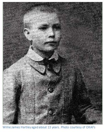
Two of those deaths occurred on the same day, the 29 May 1870. They were William “Willie” James Hartley, the seventeen year old son of Henry “Oude baas” Hartley, the elephant hunter, and James O’Donnell. Their gravesites unlike all the others were recorded in detail by Thomas Leask and Thomas Baines and so there seemed some likelihood of finding them.[iii]
Thomas Leask buried the two young men and three months later showed Henry Hartley the site of his son’s grave. Thomas Baines made a sketch and Robert Jewell took a photograph, but the location quickly became lost.
Today the Mhondoro Communal lands are heavily populated: in 1870 the land south of the Umfuli (now the Mupfure) was almost completely uninhabited due to amaNdebele raids and only became populated after 1897 with land resettlement schemes.
EE Burke was the Principal Archives Officer at the Rhodesian National Archives and wrote the first article on Willie Hartley in Rhodesiana No 8 from 1963 and thought he had located the gravesite near the Tumbwi stream near Mashayamombe Training Centre.
A few years later the Salisbury (now Harare) North Exploration Young Farmers Club (YFC) organised an expedition to find the lost grave and after a great effort believed they were successful in their search.
Thomas Baines had relied on dead reckoning for his positioning and gave a longitude of 30⁰59′E for the gravesite which is some 60 kilometres away and east of Beatrice. The YFC give a corrected longitude of 30⁰27′29.00″E but this is also 3.2 kilometres east of the site they identify as the actual gravesite!
It was time to revisit the area and use the YFC sketch maps to try and relocate Willie Hartley’s gravesite and get an accurate GPS position.
[i] Paul Jebe died of fever somewhere between Hartley Hill and Umtigesa’s kraal. Although Baines marked the gravesite on his maps there is no indication in his diary that he ever visited it and the map reference should be viewed as very approximate
[ii] Henry McGillewie’s gravesite was not visited by Baines, the only reference being that it was close to the Serui river and therefore not far from Hartley Hill
[iii] There are no references in either Leask’s or Baines’ diaries to visiting the gravesites of Mrs George Wood, their child and Mrs Fraser.
The area is south of the Mupfure River and best reached from the main Harare Bulawayo A5 National road 71 km from Harare, by turning left off the National road at the roundabout, south toward Ngezi Mine. At 4.2 km pass Chengeta Safari Lodge turnoff on the left and at 14.6 km cross the Mupfure River. At 21.7 km turn left for the Mhondoro Communal Lands and travel east.
At 8.4 km cross the Chirundazi Stream. Note the old drift on the downstream side of the low level bridge. Continue another 0.7 km and turn left at the Cape to Cairo shops.
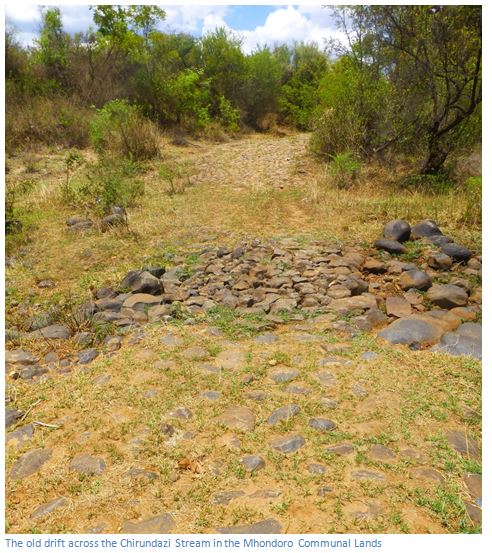
Both EE Burke and the Young Farmers Club James believed that O’Donnell’s gravesite was reached by turning right down a farm track after 0.85 km and then 400 metres to the southern end of the rocky outcrop.
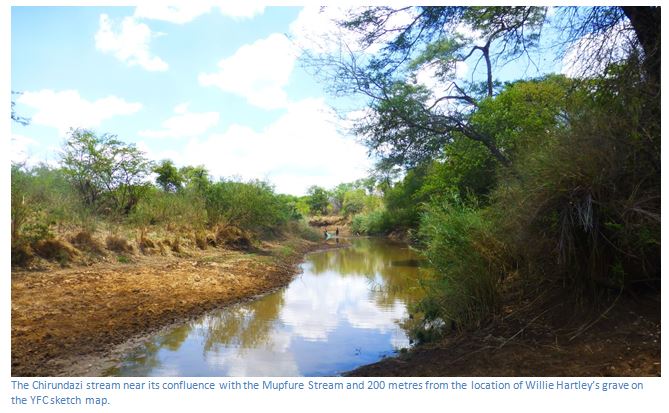
For Willie Hartley’s gravesite based on the Young Farmer’s Club explorations travel 3.0 km from the Cape to Cairo Shops and then turn left in front of a Mhondoro Primary School. Don’t look for any assistance from the School Headmaster as he is unhelpful. There are a number of rough farm tracks which lead west towards the Chirundazi Stream approximately two kilometres way. Park once the track becomes impassable and follow the footpaths down to the banks of the Chirundazi stream. Their map marks the gravesite on the eastern bank of the Chirundazi.
Approx GPS reference for Willie Hartley’s grave: 18⁰16′44″S 30⁰27′28″E
Approx GPS reference for James O’Donnell’s grave : 18⁰14′56″S 30⁰27′24″E
EE Burke was the first to try and trace the gravesite of Willie Hartley, who he says died to the south west [should be south east?] of Hartley Hill. His account in Rhodesiana No 8 of 1963 is mostly taken from Thomas Leask’s diaries which record the various groups movements in detail:
May 1870 Timeline
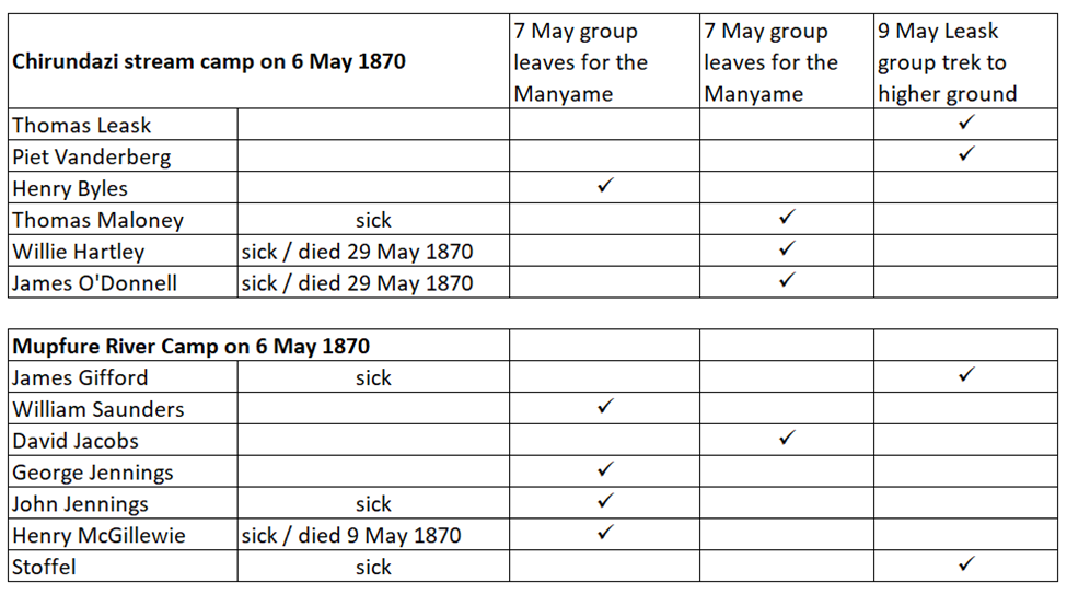
05-May | Thomas Maloney and Piet Vanderberg outspan on the Chirundazi stream two hours trek back from the Mupfure river. Thomas Leask and Henry Byles continue on to the Mupfure (Umfuli) where they find James Gifford, William Saunders, George and John Jennings, Henry McGillewie and Stoffel camped at the Mupfure river camp (on the south bank one kilometre downstream from the Mupfure / Chirundazi confluence) Four of the hunters (Gifford, John Jennings, McGillewie and Stoffel) are sick with fever. Leask persuades Gifford, an old friend, to take his ox-wagon back up the Chirundazi stream to where Thomas Maloney and Piet Vanderberg are camped and advises the other hunters to do the same. |
06-May | Willie Hartley and James O'Donnell arrive at the Chirundazi camp. Leask tries to persuade them all to move to higher ground to the south east which he believes is safer from malaria. |
07-May | The Jennings brothers, William Saunders, Henry Byles and Henry McGillewie ignore the advice and trek away north across the Mupfure for the Manyame (Hunyani) river. |
09-May | Hartley, O'Donnell and Maloney also trek away north for the Manyame river. Leask with Vanderberg, Gifford and Stoffel trek south east to higher ground. Henry McGillewie dies this day on the Serui river of fever.[i] |
14-May | Leask and party continue south east in cold wind and rain. |
15-May | Leask and Vanderberg then turn around and ride north from their camp to trade with the Mashona on the north bank of the Mupfure for chickens and pumpkins for the two invalids, Gifford and Stoffel. |
17-May | Leask and Vanderberg are at the Mupfure river, the weather is cold. |
19-May | Heavy rains make travel slow. |
21-May | Leask and Vanderberg cross to the north bank of the Mupfure river to the Mashona villages to barter for food; nobody lives on the south side. |
23-May | Leask gets a message that Maloney, Hartley and O'Donnell are back at the Chirundazi stream; all are sick and have no medicines. |
25-May | Leask and Vandeberg trek back to the camping place where Gifford and Stoffel are waiting for fresh food. |
26-May | Leask leaves at sunrise by horse and gets to where Maloney, Hartley and O’Donnell are camped on the Chirundazi stream by sunset. Hartley and O’Donnell are seriously ill and at times delirious. “He (Hartley) was extremely weak and tho' he knew me and spoke somewhat sensible, he looked wild. Jim (O'Donnell) was tossing about in great pain and seemed sensible. He said his bowels had not been open for three days. Tom (Maloney) was spitting continuously and calling for water. Gave them all calomel and antimonial powder and two hours afterwards jalap and rhubarb. They slept a little.” |
27-May | They seemed to rally with the medicines. “Gave him some salts and Jim at his own request some Livingstone pills. Will, I gave no more purgatives. Shortly after, the medicine operated on them all and they seemed much revived, but Will was very weak. They asked me to move them up towards our wagons (where Vanderberg, Gifford and Stoffel were camped) and as they seemed to think it would do them good, I inspanned after they had all supped a little arrowroot and trekked very gently for a short distance. They seemed a little better, but at sundown Will became insensible and unable to move.” |
29-May | Willie Hartley died at midday. James O'Donnell died the same evening. |
30-May | Leask moved the wagons south and rejoined Vanderberg, Gifford and Stoffel writing: “It was a very trying journey.” |
The Hunters in Mashonaland in May 1870
William (Willie) Hartley was the youngest seventeen year old son of the famous hunter, Henry Hartley, and during the early part of 1870, travelled to the rich ivory hunting grounds of Mashonaland. The year was a disastrous one for the seasonal hunters as wet weather persisted until May, and malaria was widespread in the hunting grounds.
Willie and his companion, James O'Donnell, trekked north west from Thaba Insimbi (Iron Mine Hill) to the Mwenezi Range and then north to the Hunter’s Road to meet up with Thomas Leask, who was camped on the Chirundazi Stream with his companions Vandenberg, Byles and Maloney.
The various individuals movements are summarised on the table below showing their original locations on 6 May 1870 and how they had dispersed within the next few days.
Thomas Baines learns of the death from fever of Willie Hartley and the others
Leask, in his diary of that time, makes no mention of Willie Hartley's grave or burial; but three months later, he took Henry Hartley to the gravesite with Thomas Baines and Robert Jewell. Leask wrote: “Exactly three months ago today we laid him under a Gondo tree and covered his grave with bushes to protect it from beasts of prey, carved the name and date, and we could do no more…a few miles from here J. O’Donnell is laid…Mr Baines took a sketch and Mr Jewell a photograph of the grave [Hartley’s] after which we parted.”
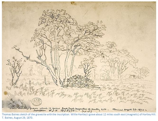
NHM (London) Baines Collection No 45: Thomas Baines sketch of the gravesite with the inscription: Willie Hartley’s
grave about 12 miles south east (magnetic) of Hartley Hill. T. Baines, August 29, 1870.
Gold Regions of South Eastern Africa account of their deaths
In his book, The Gold regions of South Eastern Africa on his second visit in 1870 to the Hartley Hills goldfield Thomas Baines writes: “I made a trip of about five and twenty miles down the Umvuli river, finding several reefs, and returned to work at the house, hoping to have it ready to receive Nelson and the working party; when two horsemen, who proved to be Maloney and Leask arrived. All our hopes of a cheerful re-union were dashed, as with a thunder-stroke, by the sad intelligence that of the little party of hunters who had come in about a month before us, no fewer than seven had died of fever, while all the rest were more or less affected. [here Baines lists George Wood’s wife and son and mother-in-law Mrs Fraser, Paul Jebe, McDonald should be Henry McGillewie, Toris [Pretorius] and Willie Hartley, but neglects to mention James O’Donnell]
He refers to: “Willie Hartley, a fine young hunter, who bade fair to rival the fame of his well-known father. His grave was about 13 miles ESE and the camp about 9 miles south east of my house. Next morning I set out to visit our friends, Mr Wood kindly sending a horse to meet me on the way, and it was sad indeed to see so many men, whom I had known so recently rejoicing in their strength, now so enfeebled in body and in mind, that they dared hardly ride a mile, even in fine weather, for the benefit of their health, and could not remember with distinctness the details of the terrible ordeal through which they had just passed.”[ii]
Northern Goldfields Diaries account of their deaths
In the Northern Goldfields Diaries Thomas Baines writes on 6 July 1870: “After an early breakfast I set out with Inyassi and two boys to visit the hunters’ camp and just before I reached Umvuli [Mupfure] met a boy with a horse which Mr [George] Wood had considerately sent to meet me. I left our wagon road and followed the track of Willie Hartley’s wagon, till I struck the main road at the Zinlundasi [Chirundazi] river and tracking this up for a mile or two reached the camp with the seven wagons were drawn of each other; but even from a distance the melancholy change wrought by a few months of sickness was apparent in the absence of the busy life, the numerous campfires and the extemporised bowers, huts scherms and other rustic shelters usually run up by the followers of a prosperous hunting parties here. Some of the waggons were absolutely tenantless and among those that were occupied it was sad to behold the sunken cheeks, the hollow eyes and pale and haggard faces of men whom I parted with so recently in the full pride of health and active strength, ready and eager for the chase of any denizen of the wilderness no matter how hard to overtake or how dangerous to fight when once come up with. [Thomas] Maloney and [James] Gifford was strong enough to make short hunting trips for the sake of meat. [Thomas] McMaster and [Thomas] Leask were absent on a more extended hunt, but [George] Wood and his brother Swithin and Mr Kennedy [?] were at home, much weakened by prolonged attacks of fever. I did not like to press for details of the recent melancholy circumstances and it seems that, as is generally the case, the convalescents had but a very confused idea of the dates and sequence of events.
But it appeared that sometime in March [George] Wood was on his way in and first was attacked by fever at the Umnyati [Munyati] river. He had then come onward, turning more to the south east up the Thaba Insimba [Iron Mine Hill] and Umtigesa highlands where he had built two houses in different places and gone over to the Sabian [Save river] side of the mountains to buy corn and goats of a chief named Umtigesi and (in returning I believe) Mrs Wood, his child and her mother, Mrs Fraser, died, as also [Paul] Jebe, who had kept a diary but burnt it a few days before his death.
Meanwhile, Willie Hartley had come in followed by [Thomas] Maloney and both crossed the Umvuli [Mupfure] passed Hartley Hill and went north ‘till Willie and his servant [James] O'Donnell took fever and they returned and must have met [George] Wood 20 or 30 miles south east of the present camp. Both the invalids died, as well as the wagon driver Toris [Pretorius] and the date of Willie’s death is cut upon a large tree under which his grave was made. McGillewie also suffered but is recovering and is away with Jennings.”[iii]
Henry Hartley with Baines, Leask and Robert Jewell visits the gravesite
There are a number of indications from Baines’ Northern Goldfields Diaries of Willie Hartley’s gravesite.
On 6 July he writes: “I left our wagon road and followed the track of Willie Hartley’s wagon, till I struck the main road at the Zinlundasi [Chirundazi] river and tracking this up for a mile or two reached the camp with the seven wagons were drawn of each other…” [P.390]
The Hunter’s road followed the Chirundazi stream on its western bank and the Chirundazi stream camp of 6 June / 6 July was between 1-2 miles (1.6 – 3 km) south of the Mupfure river.
On 26 August when Baines, Henry Hartley, Leask and Robert Jewell are being guided by Thomas Leask to Willie Hartley’s gravesite he writes: “We off-saddled for 20 minutes and then reached the Umvuli [Mupfure river] where we counted the tracks of eleven bulls crossing to the south-ward. We gave our horses 20 minutes more and ate a bit of nicely salted eland beef Mr Hartley had brought. In another hour, or a little more, we crossed the waggon track and Leask intimated quietly to me and Jewell that Willie’s grave was to our left.”
An hour on horseback would indicate the party were about 4 miles (6.5 km) south of the Mupfure river on the western bank of the Chirundazi with the gravesite to their east across the stream.
Zimfieldguide approximate position for Willie Hartley’s gravesite
On the Google Earth graphic below I have indicated the approximate position 6.5 km south of the Chirundazi / Mupfure confluence in green. The horsemen rode south on the western side of the Chirundazi – indeed the Hunter’s Road was on the western side as it follows the watershed north with small tributaries flowing west to an un-named stream flowing into the Mupfure on Riversdale Farm and east to the Chirundazi.
The hunter’s camp must have been situated nearer the Mupfure on the northern section of Avondale Estate.
In the account below from the Northern Goldfields Diaries the horsemen crossed the Chirundazi close to its confluence with the Mupfure. The terrain is much more broken up and hilly on the eastern side of the Chirundazi and it took longer to ride the 6.5 km to the gravesite (1½ hours versus 1 hour on the western side)
The Northern Goldfields Diaries description of the visit to the gravesite
On 29 August 1870 Thomas Baines wrote in his diary that they rode to the hunter’s wagons at the Umvuli drift: “We [Baines, Leask, Henry Hartley and Jewell] rode south west to the camp where I had first visited the hunters on the Zinlundusi [Chirundazi stream] Then turning east we crossed the river and, riding about an hour and a half more, we reached the spot where poor Willie Hartley’s grave had been made three months before. There was some satisfaction in seeing that the grass fires which had devastated the country around had not yet reached this spot, and that the huts and scherms and the branches heaped over the grave still remained just as they were left. Two trees overshadowed it (Umghondie, I believe) [probably Msasa, brachystegia spiciformis] one still green and dark, the other sere and yellow, but still retaining its full foliage and the inscription “W.J.H. 29/5/70” was still sharp and clear on one of the principal stems. There were no stones near which to make a cairn and probably in a few years the tree may be destroyed and all traces of the locality effaced, but it will be long before the memory of poor Willie and the other victims of this fatal year passes from the minds of either the natives, or the white men occupying this country…we returned on a course of 340 or nearly north west magnetic to the Zinlundusi River which we crossed near its junction with the Umfuli.”
In this description the party start at the Umfuli drift, cross to the eastern bank of the Chirundazi stream and then ride for 1½ hours – they very likely took a more circuitous route to the east as the countryside is much more broken and hilly closer to the stream – no mention of re-crossing the stream is another indication that the gravesite is on the eastern side.
The ‘Oude Baas’ Henry Hartley had been horrified to hear of the death of his favourite son; he became very subdued and did not resume hunting, but just pottered around prospecting. He had been hunting in the area of the Ramaquaban river and shot a rhino and saw it fall. He went up to it, thinking it was dead. Instead, it struggled to its feet and tossed him into the air. He came down on its back. As the rhino turned to get him it fell dead, literally on top of Hartley, breaking several of his ribs and generally injuring him internally so much that he died at the age sixty-one on his farm “Thorndale" in the Magaliesberg on the 8th February 1876 as a delayed result of this misadventure.
No mention is made of Henry Hartley making any additions to his son’s grave and he never returned to the site again.
EE Burke’s search for Willie Hartley’s grave written in Rhodesiana No 8 of 1963
The actual grave site has been, owing to the passing years, shrouded in mystery. It is known that Leask carved William Hartley's name and the date of his death on a tree which stood at the head of the grave and Baines's Gold Region of South Eastern Africa gives a longitude and latitude position. But time, nature and the deaths of those involved have combined forces in such a way as to create a mystery regarding William Hartley's final resting place.
EE Burke’s article is well researched as one might expect, but in his physical search for the grave I think he made a number of errors in his assumptions:
(1) That the gravesite was one and half hours horse ride east of the Zinlundasi [Chirundazi Stream]
(2)He relied on Thomas Baines’ estimate in his book Gold Regions of South Eastern Africa that the distance from “Hartley Hills to Willie’s grave” as 13 miles by trocheameter [a device that counts the revolutions of a wheel to calculate distance]
(3)He relied too literally on a sketch map in the Zimbabwe National Archives of the area east of the Chirundazi stream endorsed “Mr Lisk’s [sic] chart from the Umfuli to the SE.” The wagon track on the map between the Chirundazi camp and a point on a “spruit to Umvuli” marked “W.H” [presumably Willie Hartley’s grave] is marked “7.” It is then “4” to another stream and another “6” to a stand place for wagons on a big spruit and nearby is marked “OD” [presumably James O’Donnell’s grave]
Burke rightly disregarded Thomas Baines calculation for his position which relied on dead reckoning and gave a longitude of 30⁰ 59′E for the gravesite; this is some 60 kilometres away east of Beatrice! Based on the sketch map Burke looked for “W.H” seven miles south-east from the Chirundazi Stream and found it on the left bank of the Tumbwi, a tributary of the Nyangweni Stream and near Mashayamombe Training Centre.
From the descriptions in the sketch maps, Burke attempted to match the actual topography on the ground; this is a notoriously difficult exercise, particularly with descriptions such as “the road over the bult.”
Salisbury North Exploration Young Farmers’ Club search for Willie Hartley’s grave
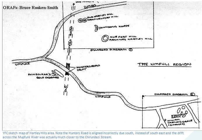
It was this sense of mystery and challenge that led the Salisbury North Exploration Young Farmers' Club (YFC) led by the late Mr Robert Bicknell to set about finding Hartley's grave sometime after 1963. The article itself on the ORAF’s site has no date. (http://rhodesianheritage.blogspot.com/2012/02/in-search-of-lost-grave.html)
The first requirement was to check out the information in EE. Burke’s paper, which put the site of Hartley's grave on the edge of a vlei leading into the Tumbwi stream from the north-west, about one mile from Mashayamombe Training Centre. I believe, though the YFC paper doesn’t say, that they realised that assumption 1 of Burke’s article was a major error and confined their search for Hartley’s grave to the area on the east bank of the Mupfure / Chirundazi confluence
Baines says “We [Baines, Leask, Henry Hartley and Jewell] rode south west to the camp where I had first visited the hunters on the Zinlundusi [Chirundazi stream] Then turning east we crossed the river and, riding about an hour and a half more, we reached the spot where poor Willie Hartley’s grave had been made three months before.” Burke assumes that the party started at the Chirundazi Stream Camp, crossed the Chirundazi and rode by horse to the east for an hour and a half.” This is about ten kilometres and could be achieved on horseback. The “W.H” site is also twenty kilometres from Old Fort Hartley; the equivalent of Baines’ thirteen miles in assumption 2.
The YFC interpreted Baines quote above differently from Burke in that the party of horsemen which included Henry Hartley, Baines, Leask and Jewell crossed the Chirundazi and followed the stream down on its east bank from its confluence with the Mupfure River.
The YFC Club first set out to find the Hunter's Road Drift over the Mupfure and try to re-trace the route as given in Baines's diary. Their account says, “the Club trekked from the southern bank of the river, through a veritable jungle of "wait-a-bit" thorn bushes before they reached the top of a bank near the weir. Beyond this was another steep bank, covered with boulders, sharp-leafed reeds, and dense undergrowth. Less than a kilometre below the weir, they found they were opposite the road on the north bank. At first it was impossible to see any signs of a road, but, after two hours of exploration, the road was seen ascending through a cutting with steep banks rising on each side. At the top, members found what they first took to be a gully, with water standing at the bottom; but, upon investigation, it was realised this was Sir John Swinburne's gold diggings, which he had worked in 1869. This was the final proof that this was Hunter's Road Drift.”
However, Thomas Baines says in The Gold Regions of South Eastern Africa on his first visit during August 1869 to the Hartley Hill goldfields: “nearly a mile to the south [of Hartley Hills] Sir John Swinburne had encamped, and with the help of his lead miner, Mr August Griete, had sunk two shafts about twenty-five feet deep, from which he had obtained some very rich, and visibly auriferous quartz, some white and crystalline, some coloured red or yellow with oxide of iron.” Note these are on the north bank of the Mupfure River, not the south bank.
In the article Thomas Baines journey to present-day Mashonaland: His first journey described from 16 February 1870 to 9 January 1871 (Vol 2) under Mashonaland West on this website in the watercolour of the Hartley Hills camp Baines’ [NHM (London) Baines Collection No 26] can be seen the windlass of the shaft dug by August Griete for Sir John Swinburne’s London and Limpopo Mining Company.
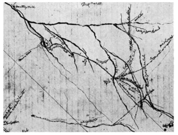
The NAZ sketch map that EE Burke relied upon in his research
The Hartley drift site is just west of the confluence of the Mupfure / Chirundazi stream
Baines’ sketch map above shows Hartley Hill in the top left and the Hartley drift across the Mupfure river just to the left of its confluence with the Chirundazi Stream with the Hunter’s Road following the west bank of the Chirundazi. The riverbanks of the Mupfure have completely changed from the 1870’s with the addition of a series of weirs which have backed up the river permanently and the old drift would now be under water.
The YFC were told by local people that there was a grave nearby, on the east bank of the Chirundazi. They say this corresponded with their calculated position from Baines original longitude position. However, the figure they give in the article of 30⁰27′29.00″E is over 3 kilometres to the east of the spot indicated on their sketch map.
Although this site is on the east bank of the Chirundazi stream, from the Northern Goldfield Diaries descriptions it is too close to the Mupfure river to be considered as the locality of Willie Hartley’s gravesite. Their sketch map has no detail apart from a tributary coming from the west and no distances are given making it unlikely it can be relied upon.
Both The YFC and Burke felt their sites corresponded exactly with Jewell’s photograph, although they acknowledged the Msasa tree would not have lived this long.
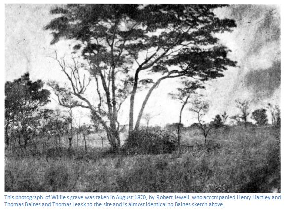
National Archives of Zimbabwe No 2897: This photograph of Willie Hartley’s grave was taken in August 1870, by Robert Jewell,
who accompanied Henry Hartley, Thomas Baines and Thomas Leask to the site and is almost identical to the Baines sketch
The prevailing soils of the area, being granite, (i.e. below 7 on a scale of 1 – 14) will give rise to acid soils and bones do not survive for long; although an entry in Henry Hartley's diary suggests that William was buried wearing the family signet ring, which was made from pure gold and contained a large ruby.
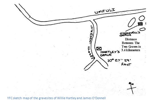
The actual gravesite is indicated on the YFC sketch map below and is shown just east of the Chirundazi Stream before its confluence with the Mupfure River and downstream of a small tributary which joins from the west.
Finally the YFC looked for James O’Donnell’s gravesite. Baines says it was no more than 4 miles from Willie Hartley’s grave, but as they rode by horse to the site, this must have been only an estimate. In the YFC article they say: “operating in pairs, the Club swept an area of 300 metres square, and eventually came across a site which, although densely overgrown, was unmistakably a grave. All information and co-ordinates checked out that this was definitely the last resting place of James O'Donnell. At the head of the grave stood a tree on which a small black area of the bark had been, at some time, blazed, leaving a mark about eight centimetres wide. The bark around the area was carefully removed; but the Club could not find any indication of an inscription and decided to leave further investigation until expert help could be obtained.”
The site indications for James O’Donnell’s grave are vague and contradictory. From Willie Hartley’s gravesite, they say the grave is in “a rocky outcrop some three miles away [4.8 kilometres] in a north north-east direction.”
The narrative above is also contradicted by the sketch map below which has O’Donnell’s gravesite south of the Mupfure River and west of the Nyangweni Stream but marked only 3.4 kilometres away!
Based on the YFC information I have placed the O’Donnell grave marker on the Google Earth graphic on the south side of a rocky wooded area which is exactly 3.4 kilometres from their suggested YFC gravesite for Willie Hartley. This rocky wooded area covered in Candelabra trees (Euphorbia ingens) extends north to the Mupfure River.
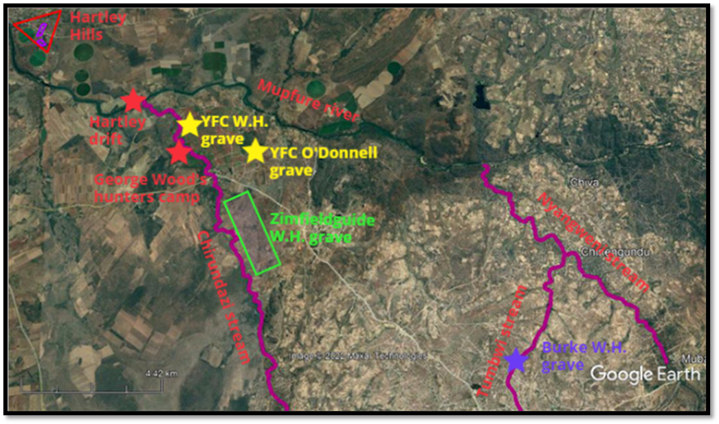
Google Earth Graphic showing suggested sites for Willie Hartley’s grave
At this time I am somewhat at a loss to explain why Willie Hartley who died at midday and James O’Donnell who died that evening were not buried side by side as they died within 6 hours of each other. Presumably Willie was buried very quickly near where he died at the Chirundazi Stream and the wagons trekked on a few more kilometres during the afternoon to where O’Donnell died and was buried on the spot.
There is nothing to indicate that the wagons moved off the Hunter’s Road on the western bank of the Chirundazi. The ground on the west is much flatter than on the eastern bank and possibly the eastern bank was chosen as a gravesite because it was above any floodwaters.
None of the party appeared to visit O’Donnell’s gravesite or any of those in George Wood’s party.
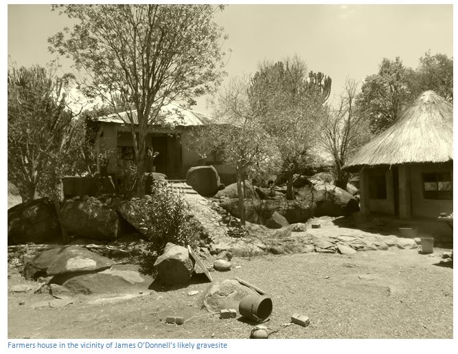
Farmers house in the vicinity of James O’Donnell’s indicated likely gravesite identified by the YFC
Henry Hartley’s letter to his son Frederick[iv] with the news of Willie’s death
Umvoolie August 20, 1870
My Dear Frederick,
It is with painful feelings I write to inform you that your poor dear Brother Willie is no more. He died the 29th of May on a little spruit between in Inloondas and Umvoolie. You cannot judge of my feelings. I loved you all equally, there is no difference in my heart and there was none to spare, but God willed it otherwise and has taken him away and I hope to a better place.
Although you have estranged yourself from me I love you with the father's fond affection and it has been a source of great grief to me. I went with Mr Leask to see where they had laid him down to his last, accompanied by Mr Baines and Jewell and Mr Baines has taken a sketch of his grave. I shall ever remember Mr Leask’s kindness with gratitude. Poor Tom[v] went down with fever at the same time and the young man who was with him died the night after him. Everyone has been down with fever but Mr Leask and in consequence of sickness nothing has been done.
I shall commence my homeward route in about 10 days or a fortnight at the fartherest (sic) and hope, if I live to return, that we shall be more united. It has not been my fault, I have done a little, but not much and I have no more heart to hunt for I miss him in the field as well as camp and I feel lost. Give my love to Sarah.
May God bless you in the earnest prayer of your bereaved father.
H. Hartley
Conclusions
(1)The search by EE Burke in 1963 was too far east and was not near either gravesite. It is a fruitless task trying to relate the features on an 1870 sketch map to the current physical features on the ground nearly a century later.
(2)The YFC Expedition reviewed the available information, made an intensive ground search, but provide no actual evidence that they actually located either Willie Hartley or James O’Donnell’s graves. No drawings apart from very rough sketch maps, no photographs, or any kind of description of the graves and contradictory information does not provide any convincing evidence that they located the gravesites.
(3)Despite our best efforts using all the available evidence at the time and the use of a GPS device, we found no trace of the graves. Local people did not move into this area until after 1897 and the area near the Chirundazi stream has only been cultivated on the east bank for the past twenty years and is still not cultivated on the west bank.
From reading the Northern Goldfields Diaries I believe it is fairly clear from Baines’ writings that Willie Hartley’s grave is ‘an hour on horseback from the Mupfure drift i.e. about 4 miles (6.5 km) south on the eastern bank of the Chirundazi stream’ as indicated on the Google Earth graphic.
There is nothing to indicate where James O’Donnell was buried although it is probable that he was buried within a few kilometres of Willie Hartley to the south as the wagons trekked to higher ground.
Acknowledgements
Thanks to ORAFs for permission to quote from Rhodesianheritage.blogspot.com/2012/02/in-search-of-lost-grave.html recompiled from the magazine Rhodesian Knowledge Number 1 about the Young Farmers Club (YFC) expedition
E.E. Burke. William Hartley’s Grave. Rhodesiana No. 8 1963.
T. Baines. The Gold Regions of South Eastern Africa. Books of Rhodesia 1968
T. Baines (Editor J.P.R. Wallis) The Northern Goldfields Diaries. Chatto and Windus, London, 1946
Brent Barber for accompanying me
Notes
[i] Henry Lamont McGillewie was a trader who became an elephant hunter because it is said he failed in business. He had a famous shooting horse named Colbrook and died of fever at the Serui River, near Hartley Hills on 9 May 1870
[ii] The Gold Regions of South Eastern Africa, P39
[iii] Northern Gold Field Diaries, P390
[iv] Frederick (1844-1902) was Hartley’s eldest son grew tobacco and coffee on a farm to the south of Hartley’s own farm, Thorndale
[v] Tom Maloney, Hartley’s son in law